 Sites List
Sites List All
Geological Sites
Natural Sites
Cultural Sites
Viewpoints
Facilities


- Kujūkushima Islands
- In the Kisakata area of Nikaho City, Akita Prefecture, there is a unique landscape of rice fields d...

- Misaki Coast
- About 3,000 years ago, andesite lava flowed westward from a crater on Mt. Chōkai, reaching the sea b...


- Nikaho City Tourism Center “Nikahotto”
- This facility contains a variety of shops with delicious products from Nikaho City, and even feature...

- Nikaho City Kisakata Local Museum
- A museum where you can learn about how Kisakata and the Kujūkushima Islands formed, as well as the l...
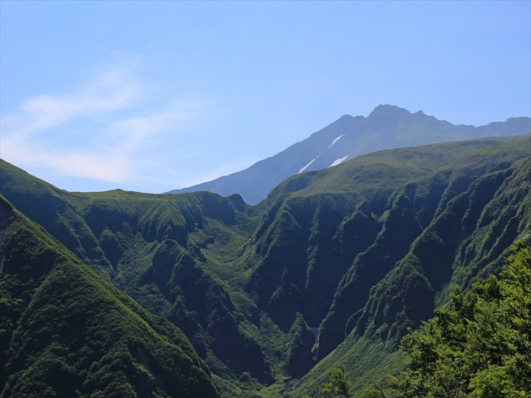
- Naso Canyon
- Naso Canyon lies north of Mt. Chōkai's 6th Station, with a depth ranging 300–500 m and a width rangi...

- Tōshi Wetland
- Tōshi Wetland is located in the Tōshi area of Nikaho City. There are many small hills scattered aro...

- Kisakata Debris Avalanche Sediments and Buried Trees
- Approximately 2500 years ago, a sector collapse occurred on Mt. Chōkai, causing a debris avalanche o...


- Takamori Overlook
- This view point is located about 230 m above sea level on Akita Prefectural Route 32, which runs fro...


- Innai Oil Field Site
- Innai Oil Field was once one of the largest oil-producing fields in Japan. An oil mining company beg...

- Nikaho Plateau
- Located at an elevation of about 500 m, this plateau was created by land that accumulated from a deb...
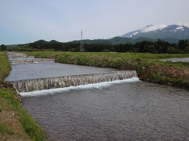
- Kamigō Warming Canals
- These canals were designed by the residents of the Kamigō area to warm the cold water from Mt. Chōka...

- Yuri Coast Seawall
- These stone walls are estimated to have been built in the 18th century (Edo period). Their purpose w...

- Karato-ishi Rock
- Karato-ishi rock was part of the sector collapse of Mt. Chōkai approximately 2500 years ago, when a ...

- Fukuden Spring
- Fukuden Spring flows from beneath a 50-m-tall cliff. This cliff was formed by lava that flowed from ...
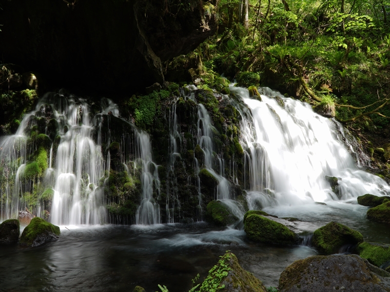
- Mototaki Springs (Waterfall)
- About a 750 m walk through the woods from the parking lot will bring you to a waterfall called Motot...

- Shishigahana Wetland, Nakajimadai
- Nakajimadai is a forest where giant Japanese beech (Fagus crenata) and mizunara oak (Quercus crispul...
- Kujūkushima Islands
- In the Kisakata area of Nikaho City, Akita Prefecture, there is a unique landscape of rice fields d...
- Misaki Coast
- About 3,000 years ago, andesite lava flowed westward from a crater on Mt. Chōkai, reaching the sea b...
- Naso Canyon
- Naso Canyon lies north of Mt. Chōkai's 6th Station, with a depth ranging 300–500 m and a width rangi...
- Tōshi Wetland
- Tōshi Wetland is located in the Tōshi area of Nikaho City. There are many small hills scattered aro...
- Kisakata Debris Avalanche Sediments and Buried Trees
- Approximately 2500 years ago, a sector collapse occurred on Mt. Chōkai, causing a debris avalanche o...
- Mototaki Springs (Waterfall)
- About a 750 m walk through the woods from the parking lot will bring you to a waterfall called Motot...
- Shishigahana Wetland, Nakajimadai
- Nakajimadai is a forest where giant Japanese beech (Fagus crenata) and mizunara oak (Quercus crispul...
- Innai Oil Field Site
- Innai Oil Field was once one of the largest oil-producing fields in Japan. An oil mining company beg...
- Nikaho Plateau
- Located at an elevation of about 500 m, this plateau was created by land that accumulated from a deb...
- Kamigō Warming Canals
- These canals were designed by the residents of the Kamigō area to warm the cold water from Mt. Chōka...
- Yuri Coast Seawall
- These stone walls are estimated to have been built in the 18th century (Edo period). Their purpose w...
- Karato-ishi Rock
- Karato-ishi rock was part of the sector collapse of Mt. Chōkai approximately 2500 years ago, when a ...
- Fukuden Spring
- Fukuden Spring flows from beneath a 50-m-tall cliff. This cliff was formed by lava that flowed from ...