 Sites List
Sites List All
Yurihonjō Area
Nikaho Area
Yuza Area
Sakata Area
Tobishima Area

- Large Fold Outcrop, Miyazawa Forest Road
- Three million years ago, tectonic plate movement began pushing on the Japanese archipelago from the ...
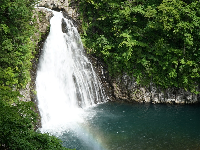
- Kameda Fudō Waterfall
- Located around 150 m above sea level, Kameda Fudō Waterfall stands about 25 m tall and 10 m wide. It...
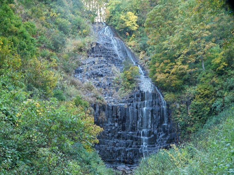
- Akata-ōtaki Waterfall
- This 23-meter-tall waterfall has an interesting shape, causing its flow to change direction near the...
- Shinzan Park (Shinzan Andesite)
- About 8 million years ago, when this area was part of a shallow sea, submarine volcanoes erupted and...
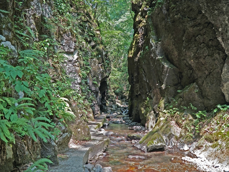
- Ishizawa Waterfall and Byōbu-iwa (Folding Screen Rocks)
- 今から3000万年ほど前はまだ日本海もなく、このあたりはユーラシア大陸の東端にありました。その当時の陸上での火山の噴火で噴出した溶岩が冷えて安山岩になり、現在地表で見られるだけでも500m以上堆積し...
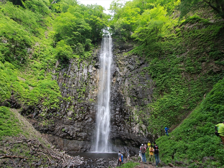
- Hiyama Waterfall
- Hiyama Waterfall is located where Sawauchi River flows over stair-like columnar joints, with an esti...
- Hottai Waterfall and Potholes
- In an eruption of Mt. Chōkai about 100 thousand years ago, a large amount of lava flowed out, creati...
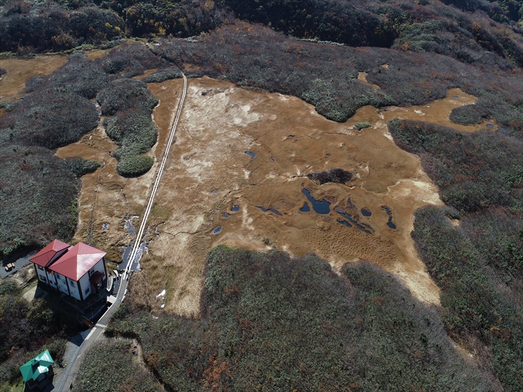
- Ryūgahara Wetland
- Located at the Yashima-guchi Trailhead of Mt. Chōkai at an elevation of 1,170 m, Ryūgahara Wetland i...
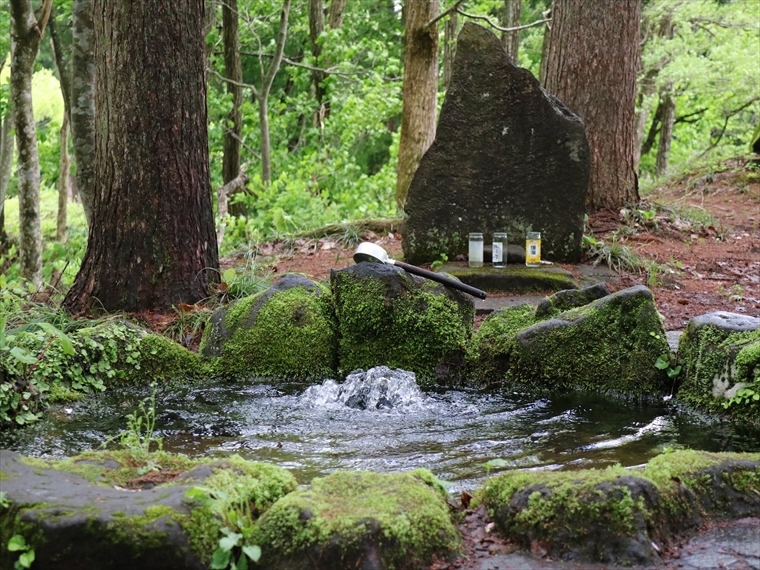
- Botsumeki Spring
- This natural spring is located on the east side of Mt. Yashio, where its steep slope changes to a ge...

- Kujūkushima Islands
- In the Kisakata area of Nikaho City, Akita Prefecture, there is a unique landscape of rice fields d...

- Misaki Coast
- About 3,000 years ago, andesite lava flowed westward from a crater on Mt. Chōkai, reaching the sea b...
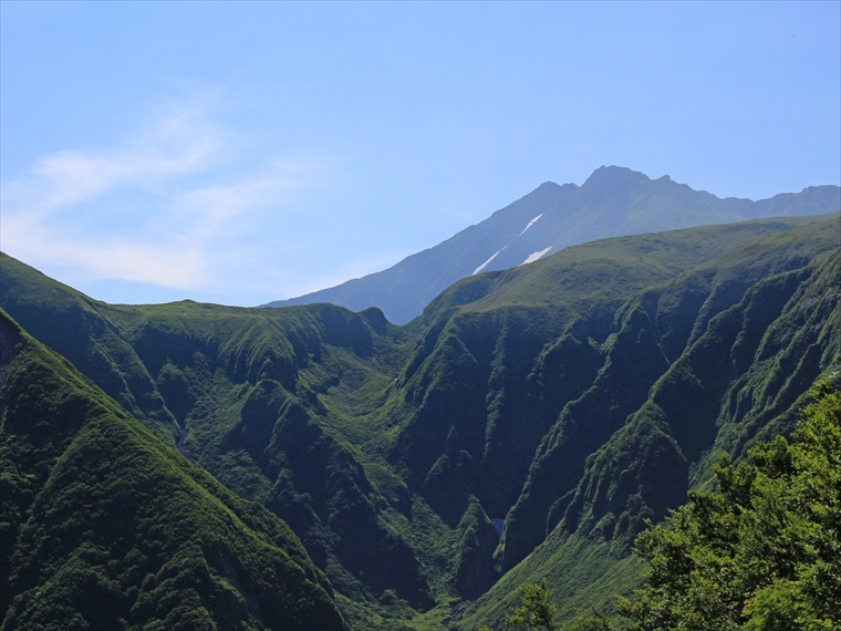
- Naso Canyon
- Naso Canyon lies north of Mt. Chōkai's 6th Station, with a depth ranging 300–500 m and a width rangi...

- Tōshi Wetland
- Tōshi Wetland is located in the Tōshi area of Nikaho City. There are many small hills scattered aro...

- Kisakata Debris Avalanche Sediments and Buried Trees
- Approximately 2500 years ago, a sector collapse occurred on Mt. Chōkai, causing a debris avalanche o...
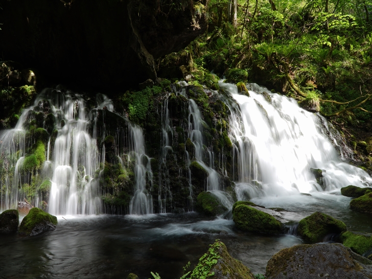
- Mototaki Springs (Waterfall)
- About a 750 m walk through the woods from the parking lot will bring you to a waterfall called Motot...

- Shishigahana Wetland, Nakajimadai
- Nakajimadai is a forest where giant Japanese beech (Fagus crenata) and mizunara oak (Quercus crispul...

- Shinzan Lava Dome and Volcanic Bombs
- The Shinzan Lava Dome formed by the eruption in 1801 has a diameter of 300 m and a relative height o...

- Normal Faults, Mt. Chōkai Mountainside
- "There are many geological faults in the Japanese archipelago. They are classified as normal faults,...

- Yuza Motomachi Springs (Artesian Wells)
- The Motomachi area in central Yuza Town is located on an alluvial fan, or fan-shaped area, where the...
- Misaki Coast
- About 3,000 years ago, andesite lava flowed westward from a crater on Mt. Chōkai, reaching the sea b...

- Kamaiso Beach
- Mt. Chōkai is made up of layers of lava from repeated volcanic activity since about 600 thousand yea...

- Dōhara Waterfalls
- Two waterfalls flow from the side of a cliff, which formed at the end of the lava flow in an eruptio...

- Chōkai Lake
- About two hours up the mountain from Hokodate Trailhead, around Mt. Chōkai 7th Station Ohama Shrine,...
御田ヶ原の流土階段(全景).jpg)
- Mt. Chōkai Periglacial Landforms
- In a cold region like Mt. Chōkai, strong winds in winter can blow away the snow, exposing the ground...

- Shōnai Plain Eastern Margin Fault Zone
- A line of straight cliffs stretches for about 38 km north to south along Route 345, between the Shōn...

- Ushiwatari River and Maruike-sama Pond
- The spring water flowing abundantly here creates a mysterious scene. In early summer, the aquatic pl...
- Shōnai Plain Eastern Margin Fault Zone
- A line of straight cliffs stretches for about 38 km north to south along Route 345, between the Shōn...

- Kaigata Perennial Snowpatch
- Located at an elevation of about 1400 m, Kaigata Perennial Snowpatch lies in a depression between mu...

- Tsuruma-ike Pond
- Along Route 368, there is a view point (known locally as “nozoki”) where you can see Tsuruma-ike Pon...
- Tamasudare Waterfall
- Tamasudare Waterfall is a 63-meter-tall waterfall located in the Dewa Mountains. It faces northwest,...

- Fudō Waterfall
- Behind Mitaki Shrine in Sakata City's Kurokawa area lies Fudō Waterfall. Standing about 20 m tall, t...

- Jūnitaki Waterfalls
- Jūnitaki is a series of twelve waterfalls in the area which show the varied and beautiful expression...

- Oshakujima Island
- Oshakujima Island is located about 1 km west of Tobishima Island and rises 72 m above sea level, hig...

- Arasaki Coast
- Tobishima Island was formed by submarine volcanic activity when the Sea of Japan was expanding. The ...

- Tobishima Tsunami Deposits
- There are several outcrops visible on the west side of Tobishima Island and in the northern Hōki are...

- Hachiman-zaki Cape
- Hachiman-zaki Cape is a cliff protruding from the northern tip of Tobishima Island. It was formed by...

- Futamata Island
- Futamata Island is entirely made up of columnar joints of a rock called basalt. These columnar joint...

- Gotoro-hama Coast
- The cliff where Tobishima Minami Lighthouse stands is 20 m high, and is composed of alternating stra...

- Eboshi Islands
- The Eboshi Islands are located about 1 km west of Tobishima Island. This group of islands features m...

- Mt. Kashiwagi and Coastal Walking Trail
- Mt. Kashiwagi, Yurijima Island, and Tateiwa Rock are a reddish color, made of a volcanic rock called...