 Geological Sites
Geological Sites All
Yurihonjō Area
Nikaho Area
Yuza Area
Sakata Area
Tobishima Area


- Shinzan Lava Dome and Volcanic Bombs
- The Shinzan Lava Dome, formed by the eruption in 1801, has a diameter of 300 m and a relative height...

- Normal Faults, Mt. Chokai Mountainside
- There are many geological faults in the Japanese archipelago. They are classified as normal faults, ...

- Kujūkushima Islands
- In the Kisakata area of Nikaho City, Akita Prefecture, there is a unique landscape of rice fields d...
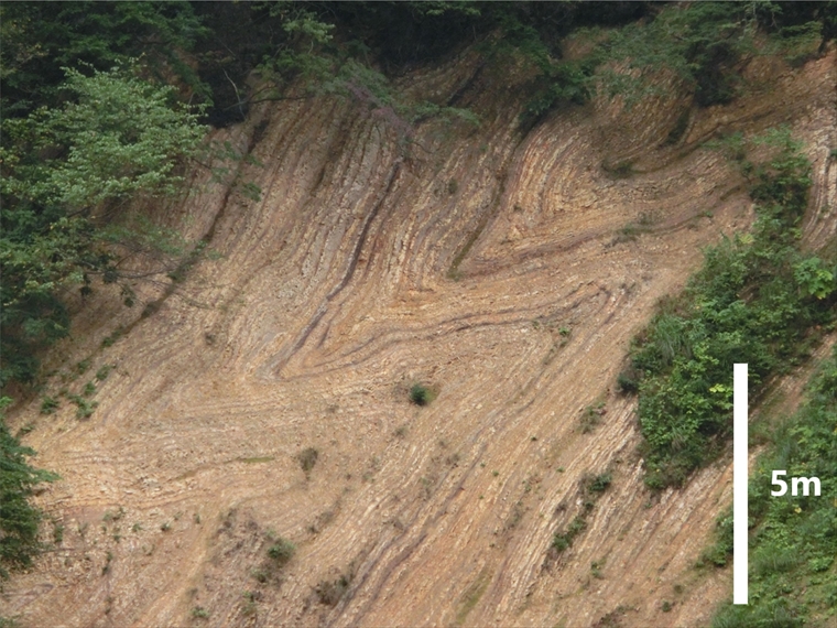
- Large Fold Outcrop, Miyazawa Forest Road
- Three million years ago, tectonic plate movement began pushing on the Japanese archipelago from the ...

- Yuza Motomachi Springs (Artesian Wells)
- The Motomachi area in central Yuza Town is located on an alluvial fan, or fan-shaped area, where the...
- Hottai Waterfall and Potholes
- In an eruption of Mt. Chokai about 100 thousand years ago, a large amount of lava flowed out, creati...
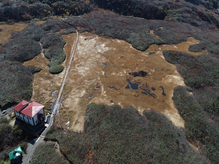
- Ryūgahara Wetland
- Located at the Yashima-guchi Trailhead of Mt. Chokai at an elevation of 1,170 m, Ryūgahara Wetland i...

- Misaki Coast
- About 3,000 years ago, andesite lava flowed westward from a crater on Mt. Chokai, reaching the sea b...

- Kamaiso Beach
- Mt. Chokai is made up of layers of lava from repeated volcanic activity since about 600 thousand yea...

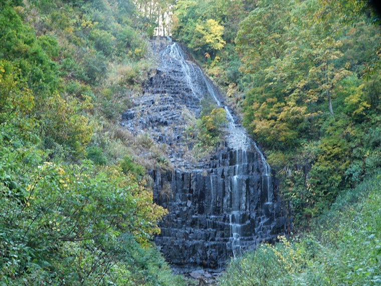
- Dōhara Waterfalls
- Two waterfalls flow from the side of a cliff, which formed at the end of the lava flow in an eruptio...

- Chokai Lake
- About two hours up the mountain from Hokodate Trailhead, around Mt. Chokai 7th Station Ohama Shrine,...
御田ヶ原の流土階段(全景).jpg)
- Mt. Chokai Periglacial Landforms
- In a cold region like Mt. Chokai, strong winds in winter can blow away the snow, exposing the ground...

- Shōnai Plain Eastern Margin Fault Zone
- A line of straight cliffs stretches for about 38 km north to south along Route 345, between the Shōn...

- Kaigata Perennial Snowpatch
- Located at an elevation of about 1400 m, Kaigata Perennial Snowpatch lies in a depression between mu...

- Tsuruma-ike Pond
- Along Route 368, there is a view point (known locally as “nozoki”) where you can see Tsuruma-ike Pon...
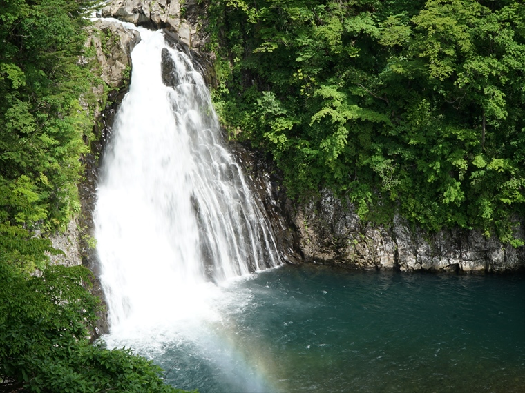
- Tamasudare Waterfall
- Tamasudare Waterfall is a 63-meter-tall waterfall located in the Dewa Mountains. It faces northwest,...

- Fudō Waterfall
- Behind Mitaki Shrine in Sakata City's Kurokawa area lies Fudō Waterfall. Standing about 20 m tall, t...

- Jūnitaki Waterfalls
- Jūnitaki is a series of twelve waterfalls in the area which show the varied and beautiful expression...

- Gotoro-hama Coast
- The cliff where Tobishima Minami Lighthouse stands is 20 m high, and is composed of alternating stra...

- Eboshi Islands
- The Eboshi Islands are located about 1 km west of Tobishima Island. This group of islands features m...

- Oshakujima Island
- Oshakujima Island is located about 1 km west of Tobishima Island and rises 72 m above sea level, hig...

- Arasaki Coast
- Tobishima Island was formed by submarine volcanic activity when the Sea of Japan was expanding. The ...

- Tobishima Tsunami Deposits
- There are several outcrops visible on the west side of Tobishima Island and in the northern Hōki are...

- Hachiman-zaki Cape
- Hachiman-zaki Cape is a cliff protruding from the northern tip of Tobishima Island. It was formed by...

- Futamata Island
- Futamata Island is entirely made up of columnar joints of a rock called basalt. These columnar joint...


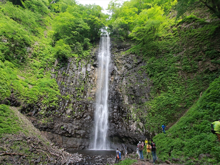
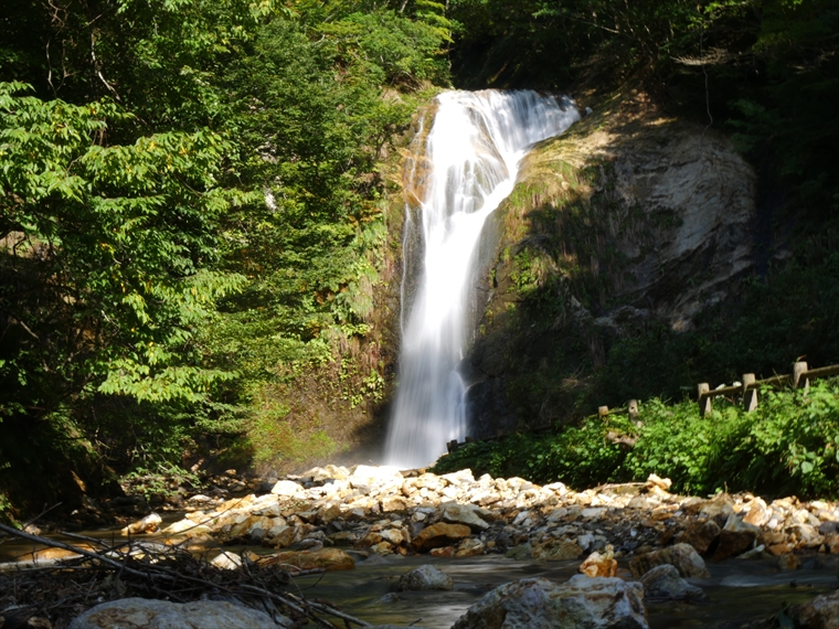
- Naso-no-shirataki Waterfall and Kinpō Shrine
- Naso-no-shirataki Waterfall is a beautiful waterfall that stands 26 m tall and 11 m wide. The rock ...

- Ushiwatari River and Maruike-sama Pond
- Ushiwatari River runs about 4 km along the edge of volcanic rock from Mt. Chokai. The river is sour...
- Kameda Fudō Waterfall
- Located around 150 m above sea level, Kameda Fudō Waterfall stands about 25 m tall and 10 m wide. It...
- Akata-ōtaki Waterfall
- This 23-meter-tall waterfall has an interesting shape, causing its flow to change direction near the...
- Shinzan Park (Shinzan Andesite)
- About 8 million years ago, when this area was part of a shallow sea, submarine volcanoes erupted and...
- Ishizawa Waterfall and Byōbu-iwa (Folding Screen Rocks)
- About 30 million years ago, before the Sea of Japan existed, this area was on the eastern edge of t...
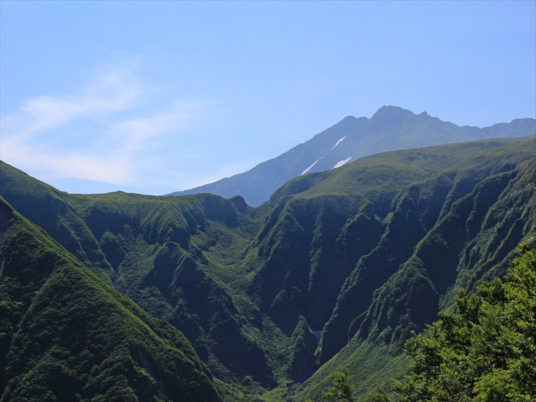
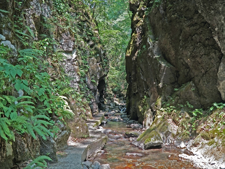
- Naso Canyon
- Naso Canyon lies north of Mt. Chokai's 6th Station, with a depth ranging 300–500 m and a width rangi...

- Tōshi Wetland
- Tōshi Wetland is located in the Tōshi area of Nikaho City. There are many small hills scattered arou...

- Kisakata Debris Avalanche Sediments and Buried Trees
- Approximately 2,500 years ago, a sector collapse occurred on Mt. Chokai, causing a debris avalanche ...
- Hiyama Waterfall
- Hiyama Waterfall is located where Sawauchi River flows over stair-like columnar joints, with an esti...
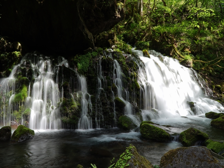
- Mototaki Springs (Waterfall)
- About a 750 m walk through the woods from the parking lot will bring you to a waterfall called Motot...

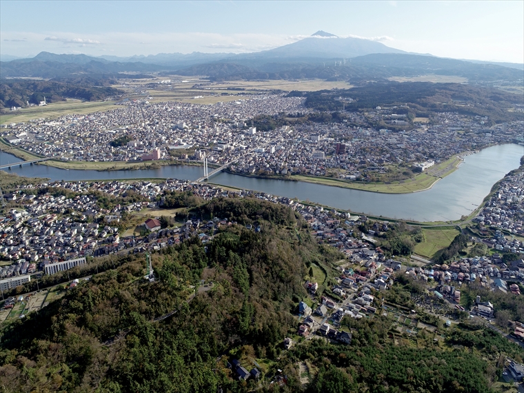
- Mt. Kashiwagi and Coastal Walking Trail
- Mt. Kashiwagi, Yurijima Island, and Tateiwa Rock are a reddish color, made of a volcanic rock called...

- Shishigahana Wetland, Nakajimadai
- Nakajimadai is a forest where giant Japanese beech (Fagus crenata) and mizunara oak (Quercus crispul...
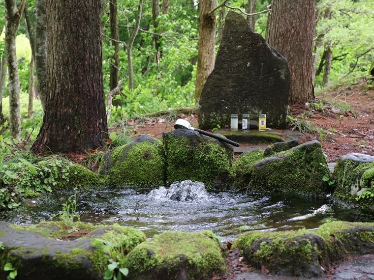
- Botsumeki Spring
- This natural spring is located on the east side of Mt. Yashio, where its steep slope changes to a ge...
- Large Fold Outcrop, Miyazawa Forest Road
- Three million years ago, tectonic plate movement began pushing on the Japanese archipelago from the ...
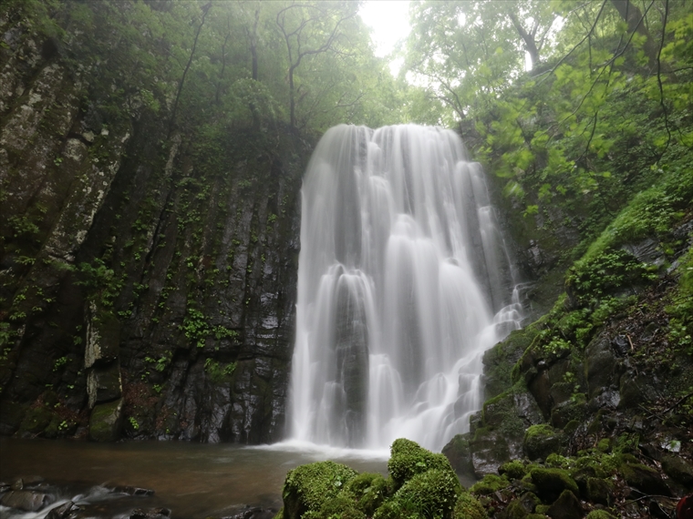
- Hottai Waterfall and Potholes
- In an eruption of Mt. Chokai about 100 thousand years ago, a large amount of lava flowed out, creati...
- Ryūgahara Wetland
- Located at the Yashima-guchi Trailhead of Mt. Chokai at an elevation of 1,170 m, Ryūgahara Wetland i...
- Kameda Fudō Waterfall
- Located around 150 m above sea level, Kameda Fudō Waterfall stands about 25 m tall and 10 m wide. It...
- Akata-ōtaki Waterfall
- This 23-meter-tall waterfall has an interesting shape, causing its flow to change direction near the...
- Shinzan Park (Shinzan Andesite)
- About 8 million years ago, when this area was part of a shallow sea, submarine volcanoes erupted and...
- Ishizawa Waterfall and Byōbu-iwa (Folding Screen Rocks)
- About 30 million years ago, before the Sea of Japan existed, this area was on the eastern edge of t...
- Hiyama Waterfall
- Hiyama Waterfall is located where Sawauchi River flows over stair-like columnar joints, with an esti...
- Botsumeki Spring
- This natural spring is located on the east side of Mt. Yashio, where its steep slope changes to a ge...
- Kujūkushima Islands
- In the Kisakata area of Nikaho City, Akita Prefecture, there is a unique landscape of rice fields d...
- Misaki Coast
- About 3,000 years ago, andesite lava flowed westward from a crater on Mt. Chokai, reaching the sea b...
- Naso-no-shirataki Waterfall and Kinpō Shrine
- Naso-no-shirataki Waterfall is a beautiful waterfall that stands 26 m tall and 11 m wide. The rock ...
- Naso Canyon
- Naso Canyon lies north of Mt. Chokai's 6th Station, with a depth ranging 300–500 m and a width rangi...
- Tōshi Wetland
- Tōshi Wetland is located in the Tōshi area of Nikaho City. There are many small hills scattered arou...
- Kisakata Debris Avalanche Sediments and Buried Trees
- Approximately 2,500 years ago, a sector collapse occurred on Mt. Chokai, causing a debris avalanche ...
- Mototaki Springs (Waterfall)
- About a 750 m walk through the woods from the parking lot will bring you to a waterfall called Motot...
- Shishigahana Wetland, Nakajimadai
- Nakajimadai is a forest where giant Japanese beech (Fagus crenata) and mizunara oak (Quercus crispul...
- Shinzan Lava Dome and Volcanic Bombs
- The Shinzan Lava Dome, formed by the eruption in 1801, has a diameter of 300 m and a relative height...
- Normal Faults, Mt. Chokai Mountainside
- There are many geological faults in the Japanese archipelago. They are classified as normal faults, ...
- Yuza Motomachi Springs (Artesian Wells)
- The Motomachi area in central Yuza Town is located on an alluvial fan, or fan-shaped area, where the...
- Misaki Coast
- About 3,000 years ago, andesite lava flowed westward from a crater on Mt. Chokai, reaching the sea b...
- Kamaiso Beach
- Mt. Chokai is made up of layers of lava from repeated volcanic activity since about 600 thousand yea...
- Dōhara Waterfalls
- Two waterfalls flow from the side of a cliff, which formed at the end of the lava flow in an eruptio...
- Chokai Lake
- About two hours up the mountain from Hokodate Trailhead, around Mt. Chokai 7th Station Ohama Shrine,...
- Mt. Chokai Periglacial Landforms
- In a cold region like Mt. Chokai, strong winds in winter can blow away the snow, exposing the ground...
- Shōnai Plain Eastern Margin Fault Zone
- A line of straight cliffs stretches for about 38 km north to south along Route 345, between the Shōn...
- Ushiwatari River and Maruike-sama Pond
- Ushiwatari River runs about 4 km along the edge of volcanic rock from Mt. Chokai. The river is sour...
- Shōnai Plain Eastern Margin Fault Zone
- A line of straight cliffs stretches for about 38 km north to south along Route 345, between the Shōn...
- Kaigata Perennial Snowpatch
- Located at an elevation of about 1400 m, Kaigata Perennial Snowpatch lies in a depression between mu...
- Tsuruma-ike Pond
- Along Route 368, there is a view point (known locally as “nozoki”) where you can see Tsuruma-ike Pon...
- Tamasudare Waterfall
- Tamasudare Waterfall is a 63-meter-tall waterfall located in the Dewa Mountains. It faces northwest,...
- Fudō Waterfall
- Behind Mitaki Shrine in Sakata City's Kurokawa area lies Fudō Waterfall. Standing about 20 m tall, t...
- Jūnitaki Waterfalls
- Jūnitaki is a series of twelve waterfalls in the area which show the varied and beautiful expression...
- Gotoro-hama Coast
- The cliff where Tobishima Minami Lighthouse stands is 20 m high, and is composed of alternating stra...
- Eboshi Islands
- The Eboshi Islands are located about 1 km west of Tobishima Island. This group of islands features m...
- Oshakujima Island
- Oshakujima Island is located about 1 km west of Tobishima Island and rises 72 m above sea level, hig...
- Arasaki Coast
- Tobishima Island was formed by submarine volcanic activity when the Sea of Japan was expanding. The ...
- Tobishima Tsunami Deposits
- There are several outcrops visible on the west side of Tobishima Island and in the northern Hōki are...
- Hachiman-zaki Cape
- Hachiman-zaki Cape is a cliff protruding from the northern tip of Tobishima Island. It was formed by...
- Futamata Island
- Futamata Island is entirely made up of columnar joints of a rock called basalt. These columnar joint...
- Mt. Kashiwagi and Coastal Walking Trail
- Mt. Kashiwagi, Yurijima Island, and Tateiwa Rock are a reddish color, made of a volcanic rock called...